Attachments:
Wednesday, January 6, 2021Categorized: Annexation, Jessica Miller, Lone Pine Real Estate LLC, Ted BerteleGilpin County Email: Roosevelt Ridge Density
Compare the following authorities:
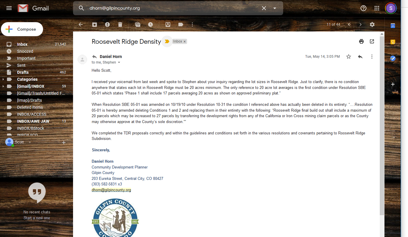
- This email by Mr. Horn contends that recorded documents are tied to the property’s title:
“AND the Roosevelt Ridge Covenants, Conditions, and Restrictions (CCR) along with the attached Resolution were recorded against their title (meaning they have to abide by the CCR and Resolution).” (emphasis original)
- The Declaration is a recorded document that states:
“the right to subdivide any Lot owned by Declarant, provided that in no event shall any Lot be less than 17.5 acres in size” (§ 12.2(a) (iii))
“No Lot or Dwelling Unit may be subdivided without the prior written consent of the Association, which consent must be evidenced on the plat or other instrument creating the subdivision. In no event shall any Lot be less than 17.5 acres in size.” (§ 15.16 (a))
- The Declaration confers controlling authority on the Design Guidelines, stating,
“Design Guidelines shall have the same force and effect as if they were set forth in this Declaration, but the terms of this Declaration shall prevail in the event of any conflict.” (§ 9.4 (a))
And the Design Guidelines state,
“Each residence will be set into a two-acre ‘building envelope’ within a 20-acre covenant protected parcel.” (page 2)
- Page 8 of the Design Guidelines adopt the Forest Management & Wildfire Mitigation Plan, which states,
“the development plan calls for approximately 20 acre lots with two acre building envelopes.” (page 10)
- The Responsible Governance Policies and Other Rules of the Roosevelt Ridge Homeowners Association confer controlling authority on the Roosevelt Ridge Illustrative Plan, which states,
“The Owner has granted the Gilpin County a Conservation Easement over the entire property that will restrict the total number of residential units to 27 which is based on minimum Lot size of 17.5 acres and includes the units associated with the existing mining claims. . . . Lots shall be at least 17.5 acres in size.”
- The Phase 1 Plat, which is recorded, states,
“Lots shall be at least 17.5 acres in size.”
- The Phase 2 plat, which is recorded, states,
“The Lots shown hereon are subject to the Declaration of Covenants, Conditions and Restrictions for Roosevelt Ridge recorded by separate instrument at reception no. ____ of the records of Gilpin County, Colorado.”
- Lone Pine’s first attorney, who helped draft the governing documents, stated:
“This project has been subdivided into 20 acre lots. 18 acres of each lot is dedicated to a conservation easement leaving 2 acres per lot available for construction of residences and ancillary structures.” (Raw Land Solutions, LLC)
- This sales’ development plan states: “Lots shall be at least 17.5 acres in size.”
- Last, in “the world according to Ted,” the 17.5-acre minimum only applies to Phase 1 lots.
Gilpin County Email: “Roosevelt Ridge Density”
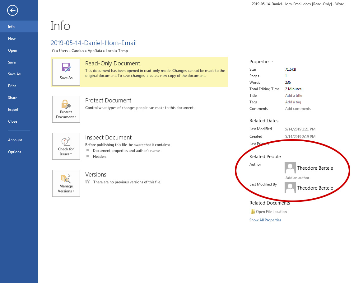
This Word Doc is not a primary-source document. It was created by Ted Bertele:
Ted Bertele “Response Letter”
Gilpin County Email: Re: Roosevelt Ridge
Roosevelt Ridge Illustrative Plan
Not on the Google Drive:
Illustrative Plan 2007
Section 4 of the Responsible Governance Policies confers controlling authority on the Illustrative Plan.
Wednesday, September 12, 2007Categorized: Charter DocumentsRoosevelt Ridge Private Reserve: Phase 1 and 2 Development Plan
“Lots shall be at least 17.5 acres in size.”
Phase 1 and 2 Development Plan
Friday, February 9, 2007Categorized: Lone Pine Real Estate LLCForest Management & Wildfire Mitigation Plan
Forest Management & Wildfire Mitigation Plan
Saturday, October 1, 2005Categorized: Charter DocumentsDesign Guidelines (2005)
The Declaration adopts the Design Guidelines as a controlling authority:
Friday, September 2, 2005Categorized: Charter Documents“Design Guidelines shall have the same force and effect as if they were set forth in this Declaration, but the terms of this Declaration shall prevail in the event of any conflict.” (§ 9.4 (a))
Declaration of Covenants, Conditions and Restrictions for Roosevelt Ridge
Declaration of Covenants, Conditions and Restrictions for Roosevelt Ridge
Tuesday, August 30, 2005Categorized: Charter DocumentsPhase 1 Final Plat
Tuesday, August 30, 2005Categorized: Charter Documents
Gilpin County Resolution Number SBE 05-01
Lone Pine executed every requirement on this list except the last clause of the last requirement, which essentially said, “No cistern, no plat”:
Gilpin County Resolution Number SBE 05-01
“Applicant shall be required to petition for annexation into a fire district and the applicant must complete any code improvements required by the district”
Tuesday, August 23, 2005Categorized: Cistern, Lone Pine Real Estate LLC